The Lens team is welcoming signs of spring with open arms! Some of us are enjoying a glimpse of summer-like temperatures, while others are firmly in mud season. This month, we're excited to share many new exciting updates, including our highest-resolution commercial imagery ever! Check out the overview here, and scroll on for more details.
📢 Latest events: New webinars for carbon projects and tax assessors
🚀 Product updates: 15cm imagery, new tools, and more
👩🏫 Education: Blog post on using the new area in range tool
🌲 Where on Earth: Celebrating International Day of Forests
.png)
Join us on April 9th at 11:00am (ET) for an interactive webinar where experts from Upstream Tech and Chloris Geospatial will showcase how these tools streamline project monitoring, enhance risk assessment, and unlock investment opportunities.
Whether you're investing in carbon projects, exploring areas for new carbon project development, or positioning carbon projects to potential investors, this session will provide actionable insights to elevate diligence and minimize risk.
.png)
Miles from our Growth & Partnerships team recently hosted a webinar discussing how county assessors can leverage publicly available satellite imagery.
In this session, we cover:
✅ Imagery with no minimum spends
✅ New imagery throughout the year instead of infrequent captures
✅ Imagery reports to supplement contestations with landowners
✅ Streamlined agricultural use monitoring
Access the recording to learn more about how Lens can be a changer for agricultural monitoring and tax assessment.
We’re now offering 15cm imagery - our highest-resolution commercial option ever! Available in the Order pane for $1.00 per acre, this ultra-detailed imagery derived from Nearmap is ideal for assessing property conditions, investigating potential easement violations, or tracking changes with more clarity than ever before.Check out our recent blog to learn more.
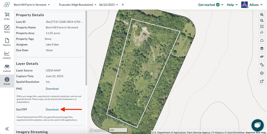
We’re thrilled to announce a new highly-requested feature: you can now download GeoTIFFs of USDA National Agricultural Imagery Program (NAIP) and Sentinel-2 (S2) public imagery directly from Lens! Download the GeoTIFF from the Details pane of a property to easily analyze the data further in your favorite geospatial tool or simply save it for future use. Learn more.
Lens measurement tools are now more powerful than ever, enabling you to measure areas on your property as well as linear distances. Click the ruler icon on the right-hand side of the property map to open the measure tool to quickly check compliance or estimate the size of a structure. Learn more.

Ever looked at a map and wondered about the exact value of a single pixel? With the new pixel info tool, you can now get precise pixel values, coordinates, and elevation data on hover. Open the pixel info tool on the right-hand side of the property map, then hover over any location to see the precise value for that dataset. To view elevation data, open 3D mode while using the pixel info tool. Learn more.
Have you ever needed to find an exact location while monitoring in Lens? With the new location search tool, now you can! Open the tool on the right-hand side of the property map then type in an exact address, coordinates, or other location and press enter to be taken directly there. Easily snap back to your property boundaries with the "Zoom to fit property" button, right above the location search.
Last month we introduced a brand new analysis tool that makes it easy to clip and save specific areas within your property where data falls within a chosen range. This blog post highlights different ways to use the area in range tool to monitor vegetation recovery after a storm, pinpointing wildfire impact, and more.

In honor of the International Day of Forests on March 21st, we're highlighting one of our favorite forested areas and extending a special thank you to the stewards who manage these important ecosystems around the world. This managed forest in New Hampshire is a stunning example of the regenerative power of forests -- just look at the difference 5 years makes!
© USDA NAIP 2018 & 2023 via Lens
The partial order tool is the perfect way to order a smaller part of a high-res commercial image to investigate a potential easement violation on a particular part of a property, or simply test out an image before ordering the whole scene. The partial order tool has a new minimum order size—10 acres, down from 100 acres—that makes it easier than ever to get exactly what you need for your remote monitoring.
Check out our knowledge base to learn more about working in Lens, and know that you can always reach us at lens@upstream.tech with any questions
Happy monitoring!
Did you know you can get this monthly newsletter right to your inbox? Subscribe for the latest updates from Lens!
.png)
.avif)

